Wells and Borings
- Request/Look-up Services
- Wells and Borings Home
- Well Tested? Well Done SE Minnesota
- CEUs
- Construction of Wells and Borings
- Contractors
- Fees
- Laws and Rules
- Licensing
- Minnesota Well Index
- Natural Disasters
- Permits
- Publications
- Resources
- Sealing of Wells and Borings
- Special Construction Areas
- Water Quality and Testing
- Water Information
- Well Disclosure
- Well Partners
Wells Program
Related Topics
- Accredited Laboratories/Well Water Testing
- Clean Water Fund
- Contaminants in Water
- Flooded Wells
- Pesticides
- Water and Health
Environmental Health Division
Lake Elmo/Oakdale
Special Well and Boring Construction Area
Memo
Lake Elmo and Oakdale Special Well and Boring Construction Area (SWBCA) went into effect 1982, and was renamed and boundaries updated on March 15, 2007. Construction, repair, and sealing of regulated wells and borings within the SWBCA may only take place in accordance with the conditions and requirements set forth in the SWBCA memo, found at: 2007 Memo (PDF).
Boundaries
The area of the Lake Elmo/Oakdale SWBCA includes the original extent, last modified in 1983, and the extent as updated in 2007.
The boundaries of the original SWBCA, were as follows:
- Northern boundary of Lake Jane Hills Park, and west following an irregular boundary of Ivy Court North to Isle Avenue North.
- The alignment of Isle Avenue North to approximately 37th Avenue north, then west to the alignment of Irvin Circle North, then south to Highway 5.
- Highway 5 on the south, between Iris Avenue North and the midpoint of Section 15 (immediately east of intersection with 31st Street North.
- The north-south centerline of Section 15 and that part of Section 10 to the north boundary of Lake Jane Hills Park.
The boundaries of the SWBCA area encompass the area described above and were revised in 2007 to include the following: (see Figure 1)
- Ramsey-Washington County line on the west (County Road 120, also known as Century Avenue or Geneva Avenue).
- Interstate 94 on the south, from county line to Lake Elmo Avenue.
- Lake Elmo Avenue on the east, extending from Interstate 94 to Highway 5 (Stillwater Boulevard North in Lake Elmo, 34th Street North in Oakdale) and, then, to 47th Street North.
- 47th Street North-Lake Jane Trail to Ideal Avenue North on the north, then southward to Highway 5, then westward to Ramsey-Washington County line.
- The area between Granada Avenue North and Hadley Avenue North, north of Highway 5 and south of 35th Street North.
The SWBCA includes all of Sections 14-16, 19-23, and 26-35 and portions of Sections 9-11, 13, 17-18, and 24, Township 29 North, Range 21 West, Washington County.
Maps
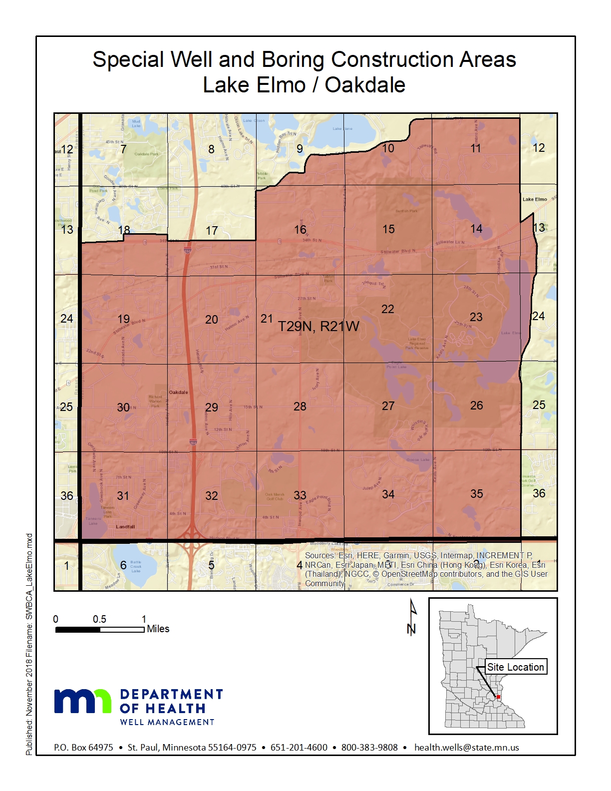
Click on map to enlarge.
Stratigraphy Map
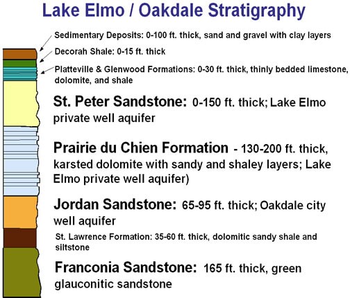
Click on map to enlarge.
Questions
Well Management Section
651-201-4600 or 800-383-9808
health.wells@state.mn.us
Go to > top