Wells and Borings
- Request/Look-up Services
- Wells and Borings Home
- Well Tested? Well Done SE Minnesota
- CEUs
- Construction of Wells and Borings
- Contractors
- Fees
- Laws and Rules
- Licensing
- Minnesota Well Index
- Natural Disasters
- Permits
- Publications
- Resources
- Sealing of Wells and Borings
- Special Construction Areas
- Water Quality and Testing
- Water Information
- Well Disclosure
- Well Partners
Wells Program
Related Topics
- Accredited Laboratories/Well Water Testing
- Clean Water Fund
- Contaminants in Water
- Flooded Wells
- Pesticides
- Water and Health
Environmental Health Division
Lakeland/Lakeland Shores
Special Well and Boring Construction Area
Memo
Lakeland/Lakeland Shores Special Well and Boring Construction Area (SWBCA) went into effect December 16, 1987. Construction, repair, and sealing of regulated wells and borings within the SWBCA may only take place in accordance with the conditions and requirements set forth in the SWBCA described below.
A Well Advisory was issued on December 16, 1987, for portions of Lakeland and Lakeland Shores, Washington County. The advisory prohibits the deepening of existing wells into lower bedrock formations or the drilling of new wells into lower bedrock formations. The advisory requires plan approval before the construction of new water-supply wells in drift or shallow bedrock aquifers.
Groundwater quality monitoring of over 360 private wells has indicated the presence of a variety of volatile organic compounds (VOCs). These compounds are solvents and petroleum products which are not naturally occurring. Contaminants have been found in 193 wells; in 86 of these wells, the levels of one or more of the VOCs exceeded the levels that are considered safe to drink. Residents in these homes were initially provided with bottled water, and have now been connected to a municipal water system. At least two sources and plumes are suspect with the northerly plume containing fluorocarbons (freon) and petroleum products, and the southerly plume containing solvents.
The geology of the site consists of alluvium averaging approximately 100 feet thick overlying bedrock ranging from the Prairie du Chien dolomite to the west, to the Mount Simon near the St. Croix River. The groundwater flow direction is generally to the southeast toward the St. Croix River.
Boundaries
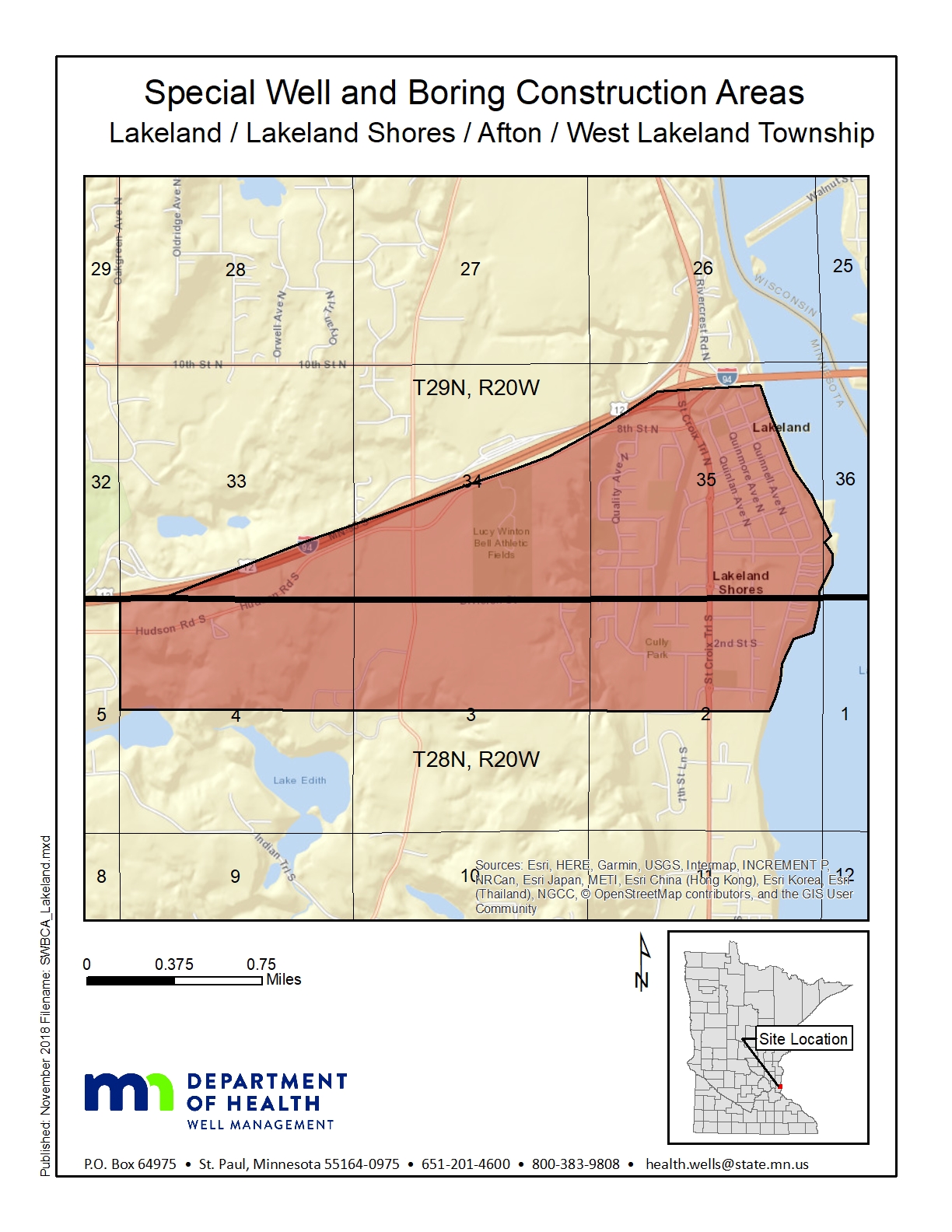
The area of the Lakeland/Lakeland Shores SWBCA includes the northern half of Section 4, the northern half of Section 3, and the northern half of Section 2, excluding the St. Croix River in Township 28 North, Range 20 West, and Sections 33, 34, and 35, except that portion of these sections north of Interstate Highway 94 in Township 29 North, Range 20 West, Washington County.
Map
Click on map to enlarge.
Questions
Well Management Section
651-201-4600 or 800-383-9808
health.wells@state.mn.us
Go to > top
